Vehicle Tracking System
Integrated drone software for autonomous vehicle tracking and real‑time situational awareness
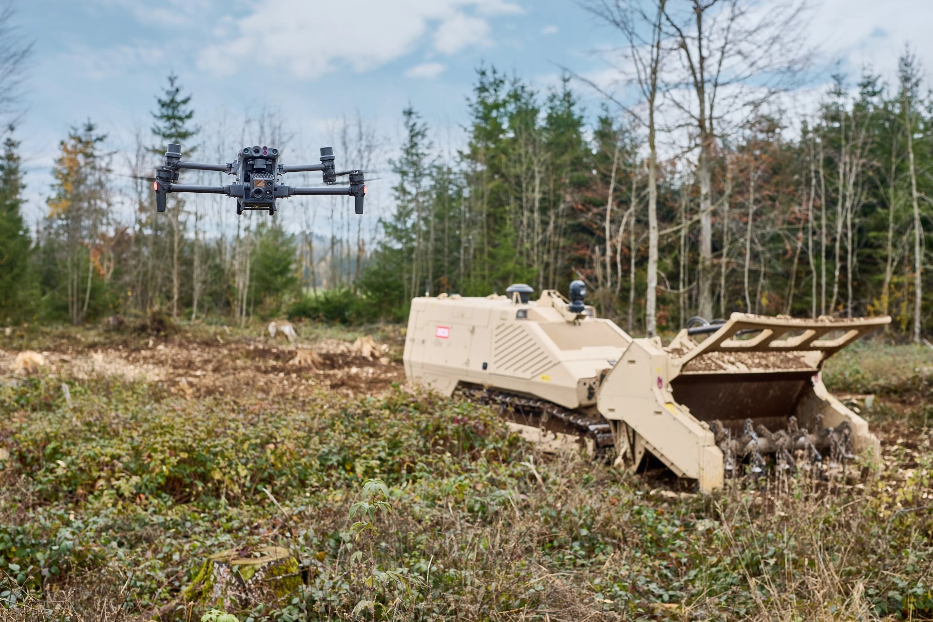
The Vehicle Tracking System (VTS) enables autonomous drone‑based tracking of clearance vehicles, providing continuous overhead visibility and situational awareness without requiring a dedicated drone operator.
During clearance, engineering and route‑opening operations, operators must maintain continuous awareness of the machine, its surroundings and the immediate progress of the task while managing risk in complex environments. From ground level, visibility is limited. Obstacles, terrain changes and the interaction between the machine and the ground are not always fully visible to the operator. Manual drone operation adds workload, requires additional personnel and can distract from the primary mission.
The Vehicle Tracking System (VTS) addresses this challenge by integrating autonomous drone tracking directly into GCS operations. The drone automatically follows the clearance or engineering vehicle, maintains predefined viewing positions and keeps the machine in frame while avoiding obstacles. The result is persistent aerial oversight that enhances situational awareness and safety while allowing the operator to concentrate fully on vehicle control and task execution.

Built for operational deployment
01
Autonomous vehicle tracking
The drone automatically follows the vehicle, maintaining altitude relative to the machine, adjusting yaw in the direction of movement and keeping the vehicle centred in view without manual input.
02
Predefined & custom viewing positions
Operators can select predefined camera positions (initial top view, close, medium, far) or define custom altitudes and distances to adapt the view to the task and terrain.
03
Obstacle avoidance in three dimensions
The system detects obstacles in the flight path and autonomously avoids them both horizontally and vertically, supporting safe operation around terrain features, structures and equipment.
04
Manual & free‑flight modes
In addition to tracking mode, the drone can be flown manually or used for autonomous reconnaissance independent of the vehicle, enabling inspections and broader area overview when required.
05
Minimal training & reduced workload
The intuitive system design allows operators to become effective quickly and eliminates the need for a dedicated drone operator during operations.
06
Continuous operation with hot‑swap batteries
Hot‑swappable batteries and automatic return‑to‑home functions help minimise interruptions and maximise operational uptime.

Operational specifications
Tracker
371 g
weight
GNSS
signal capabilities
Up to
18 hours
battery life
LoRa
transmittion protocol
22 dBm
transmitter power
1Hz
position update rate
Capabilities this platform supports
Capabilities this platform supports
Capabilities this platform supports
Capabilities this platform supports

Demining (Humanitarian Mine Action)
Restoring safe land access through structured, evidence-based mine action and land release

Battle Area Clearance
Restoring controlled land use across former battle areas contaminated by explosive ordnance

Range Clearance
Restoring safe and usable land across contaminated training and impact areas

Urban Clearance
Restoring controlled access and functionality in explosive‑contaminated urban environments

Combat Engineering
Shaping battlefield environments to support mobility, protection and control in high-threat environments

Minefield Breaching
Creating controlled lanes through mine and obstacle threats to support manoeuvre under operational pressure

Explosive Ordnance Disposal (EOD)
Managing explosive ordnance hazards that block recovery, operations and access

IEDD & Search
Managing improvised explosive threats that block access, movement and recovery
Capability availability depends on regulatory environment, drone configuration and mission context.
Demining (Humanitarian Mine Action)
Restoring safe land access through structured, evidence-based mine action and land release
Battle Area Clearance
Restoring controlled land use across former battle areas contaminated by explosive ordnance
Range Clearance
Restoring safe and usable land across contaminated training and impact areas
Urban Clearance
Restoring controlled access and functionality in explosive‑contaminated urban environments
Combat Engineering
Shaping battlefield environments to support mobility, protection and control in high-threat environments
Minefield Breaching
Creating controlled lanes through mine and obstacle threats to support manoeuvre under operational pressure
Explosive Ordnance Disposal (EOD)
Managing explosive ordnance hazards that block recovery, operations and access
IEDD & Search
Managing improvised explosive threats that block access, movement and recovery
Capability availability depends on regulatory environment, drone configuration and mission context.
Related mission package components
Integrated Software Solutions


Unmanned Platforms


Support & Field Equipment

Operational Support


Related mission package components
Integrated Software Solutions
Unmanned Platforms
Support & Field Equipment
Operational Support
Related mission package components
Integrated Software Solutions
Unmanned Platforms
Support & Field Equipment
Operational Support
Related mission package components
Integrated Software Solutions
Unmanned Platforms
Support & Field Equipment
Operational Support
Operational experience from the field, across contexts and missions.
Operational experience from the field, across contexts and missions.
Operational experience from the field, across contexts and missions.
Operational experience from the field, across contexts and missions.


Configure the right system for your task
GCS helps define the right platform, attachments, sensors and support package based on threat type, terrain and mission requirements.
Configure the right system for your task
GCS helps define the right platform, attachments, sensors and support package based on threat type, terrain and mission requirements.
Configure the right system for your task
GCS helps define the right platform, attachments, sensors and support package based on threat type, terrain and mission requirements.
Configure the right system for your task
GCS helps define the right platform, attachments, sensors and support package based on threat type, terrain and mission requirements.
Vehicle Tracking System
Vehicle Tracking System
Vehicle Tracking System
Vehicle Tracking System
Integrated drone software for autonomous vehicle tracking and real‑time situational awareness