Recon
Integrated drone software for autonomous reconnaissance, mapping and inspection

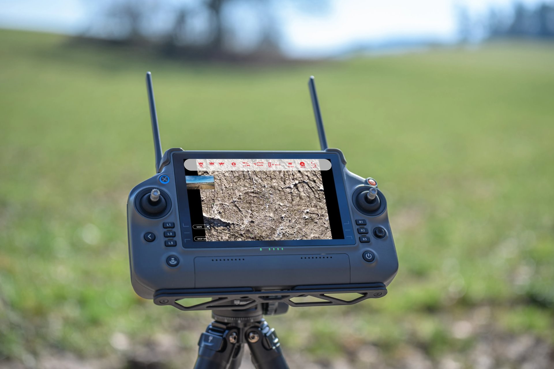
GCS Recon enables structured aerial reconnaissance using drones, supporting survey, inspection and documentation tasks before, during and after clearance operations. The software combines mission planning, autonomous flight execution and high‑resolution data analysis in a single, controlled workflow.
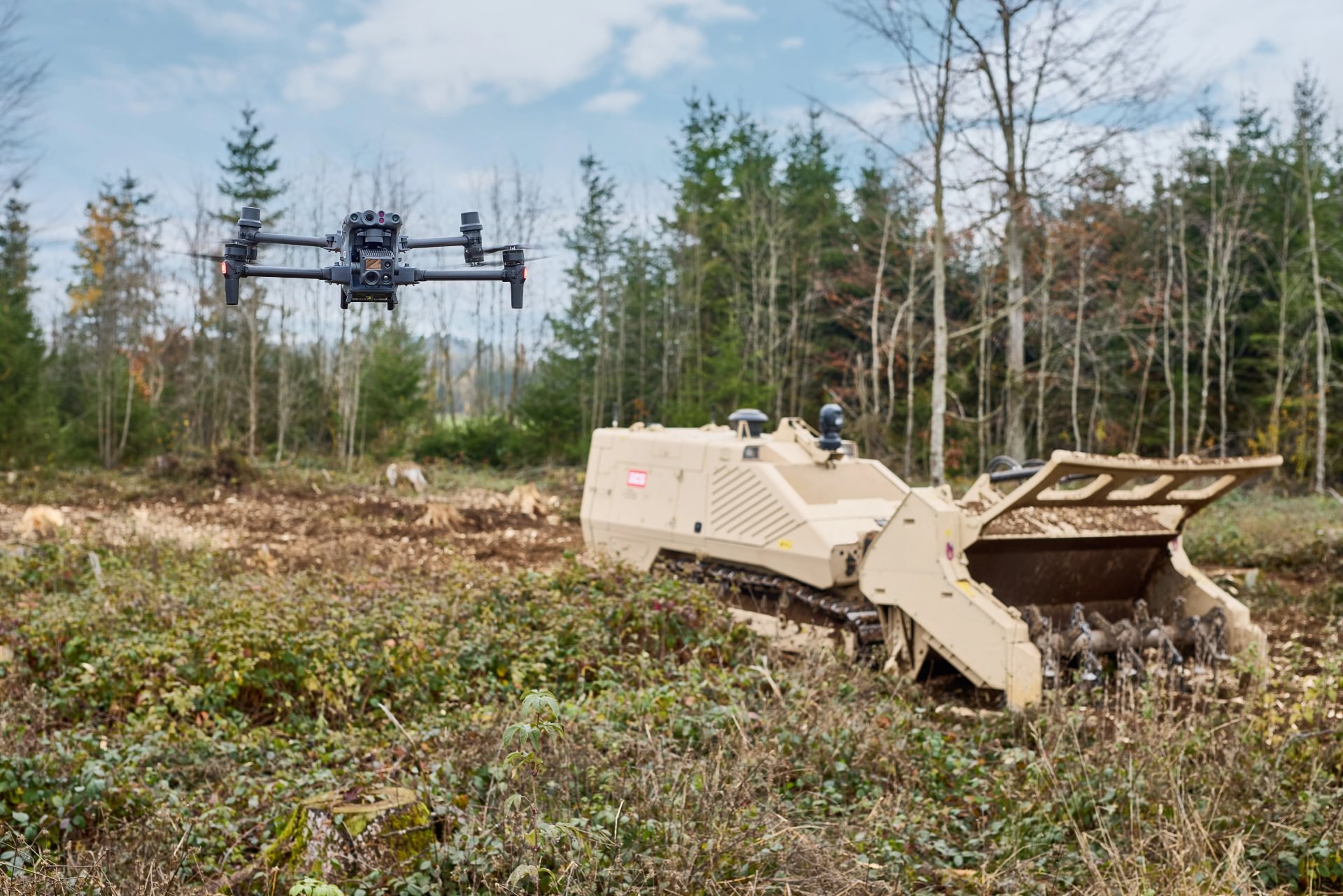
Before clearance, engineering or recovery activities can begin, operators need a clear understanding of the area of interest. Ground‑based observation alone often provides limited overview, while manual drone operation can be time‑consuming, inconsistent and dependent on specialised operators. GCS Recon addresses this need by enabling autonomous reconnaissance missions that deliver consistent, georeferenced aerial data with minimal operator input.
Missions are planned in advance on a desktop application and executed autonomously by the drone in the field. The resulting imagery is processed locally into orthographic maps and high‑resolution inspection images that support analysis, documentation and decision‑making.
Recon is designed for permissive and semi‑permissive environments where time allows for structured survey and where reliable spatial data is required to support clearance planning, progress monitoring and quality assurance.
GCS Recon enables structured aerial reconnaissance using drones, supporting survey, inspection and documentation tasks before, during and after clearance operations. The software combines mission planning, autonomous flight execution and high‑resolution data analysis in a single, controlled workflow.
Before clearance, engineering or recovery activities can begin, operators need a clear understanding of the area of interest. Ground‑based observation alone often provides limited overview, while manual drone operation can be time‑consuming, inconsistent and dependent on specialised operators. GCS Recon addresses this need by enabling autonomous reconnaissance missions that deliver consistent, georeferenced aerial data with minimal operator input.
Missions are planned in advance on a desktop application and executed autonomously by the drone in the field. The resulting imagery is processed locally into orthographic maps and high‑resolution inspection images that support analysis, documentation and decision‑making.
Recon is designed for permissive and semi‑permissive environments where time allows for structured survey and where reliable spatial data is required to support clearance planning, progress monitoring and quality assurance.

Built for operational deployment
01
Mission planning on satellite imagery
Inspection areas, flight altitude and camera settings are defined directly on satellite imagery, enabling precise and repeatable mission preparation.
02
Autonomous reconnaissance flights
Once started, missions are executed autonomously by the drone, including take‑off, waypoint navigation, image capture, obstacle avoidance and return‑to‑home.
03
Orthographic image generation
Captured images are automatically merged into a georeferenced orthophoto that provides a complete overview of the surveyed area.
04
High‑resolution inspection imagery
In addition to overview images, high‑resolution photographs enable detailed inspection of points of interest within the mission area.
05
Measurement & georeferencing tools
Objects and areas can be marked, measured and georeferenced, supporting distance and area assessments directly within the software.
06
Stand‑alone, local installation
GCS Recon runs as a local installation on the operator’s computer. No cloud connectivity is required for data processing or storage.

Operational specifications
Desktop application
for mission planning and data analysis
Remote‑controller application
for mission execution
Autonomous waypoint‑based
flight execution
Local
image processing and orthophoto generation
Measurement and annotation
of georeferenced imagery
Capabilities this platform supports
Capabilities this platform supports
Capabilities this platform supports
Capabilities this platform supports

Demining (Humanitarian Mine Action)
Restoring safe land access through structured, evidence-based mine action and land release

Battle Area Clearance
Restoring controlled land use across former battle areas contaminated by explosive ordnance

Range Clearance
Restoring safe and usable land across contaminated training and impact areas

Urban Clearance
Restoring controlled access and functionality in explosive‑contaminated urban environments

Combat Engineering
Shaping battlefield environments to support mobility, protection and control in high-threat environments

Explosive Ordnance Disposal (EOD)
Managing explosive ordnance hazards that block recovery, operations and access

IEDD & Search
Managing improvised explosive threats that block access, movement and recovery

Minefield Breaching
Creating controlled lanes through mine and obstacle threats to support manoeuvre under operational pressure
Capability availability depends on regulatory environment, drone configuration and mission context.
Demining (Humanitarian Mine Action)
Restoring safe land access through structured, evidence-based mine action and land release
Battle Area Clearance
Restoring controlled land use across former battle areas contaminated by explosive ordnance
Range Clearance
Restoring safe and usable land across contaminated training and impact areas
Urban Clearance
Restoring controlled access and functionality in explosive‑contaminated urban environments
Combat Engineering
Shaping battlefield environments to support mobility, protection and control in high-threat environments
Explosive Ordnance Disposal (EOD)
Managing explosive ordnance hazards that block recovery, operations and access
IEDD & Search
Managing improvised explosive threats that block access, movement and recovery
Minefield Breaching
Creating controlled lanes through mine and obstacle threats to support manoeuvre under operational pressure
Capability availability depends on regulatory environment, drone configuration and mission context.
Related mission package components
Integrated Software Solutions

Support & Field Equipment


Related mission package components
Integrated Software Solutions
Support & Field Equipment
Related mission package components
Integrated Software Solutions
Support & Field Equipment
Related mission package components
Integrated Software Solutions
Support & Field Equipment
Operational experience from the field, across contexts and missions.
Operational experience from the field, across contexts and missions.
Operational experience from the field, across contexts and missions.
Operational experience from the field, across contexts and missions.


Configure the right system for your task
GCS helps define the right platform, attachments, sensors and support package based on threat type, terrain and mission requirements.
Configure the right system for your task
GCS helps define the right platform, attachments, sensors and support package based on threat type, terrain and mission requirements.
Configure the right system for your task
GCS helps define the right platform, attachments, sensors and support package based on threat type, terrain and mission requirements.
Configure the right system for your task
GCS helps define the right platform, attachments, sensors and support package based on threat type, terrain and mission requirements.
Recon
Integrated drone software for autonomous reconnaissance, mapping and inspection